
North ChaTian Mountain 北插天山 is one of Northern Taiwan's most well known mid-range mountains. It is famous for the autumnal colours of leaves that aren't normally seen in Taiwan at lower elevations. However, it is also well known as a good place to practice and train for high mountain hikes.

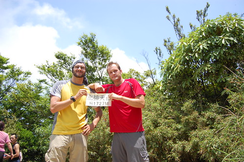
North ChaTian Mountain stands at 1727m above sea-level, which isn't particularly high but it still feels like the high mountains in other parts of Taiwan. And the best thing is there's no altitude sickness and no long drive to get to the trail head! I've done many hikes around Taipei and while they are fantastic, nothing has compared to this one.

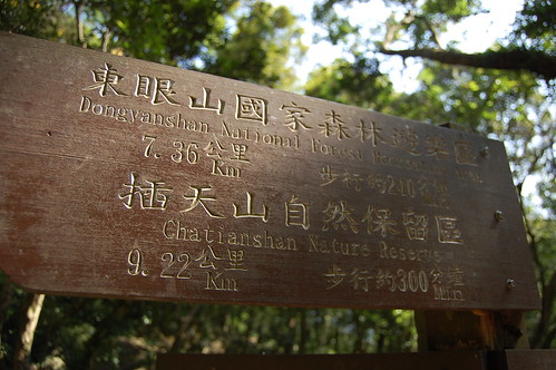
There are four main trials that lead to North ChaTian Mountain. You can start at Manyueyuan 滿月圓, Dongyuanshan 東眼山, Xiao Wulai 小烏來 or Fushan 福山. The easiest of which starts at Xiao Wulai, however we decided to begin the hike at Manyueyuan as we'd been there before and knew exactly where the trial began.
Getting to Manyuyuan without your own transport isn't easy. There is a bus that goes to Lelegu 樂樂谷 from Sanxia 三峽 but after that you need to walk 50mins just to get to Manyueyuan and considering the hike is 22km, the extra walk wouldn't be all that welcome. Perhaps a taxi from Sanxia or Yongning MRT would be best.
At Manyueyuan we met a guy selling hiking gear, including the Taiwanese favourite, wellington boots. He said he hikes North ChaTian Mountain every Sunday. I asked him if he wanted to climb anything else and he said no! Though after finishing it, I can understand why.
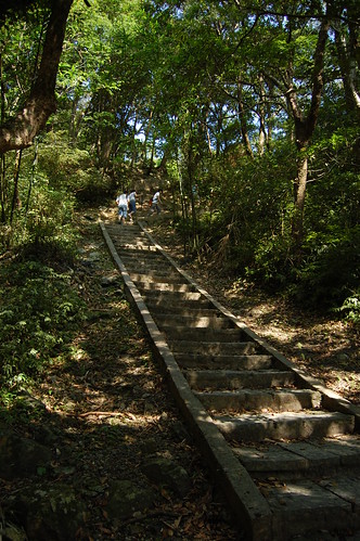
We entered Manyueyuan at 8.30, paid the entrance fee and followed the path towards the visitor centre where you can get some basic snacks and drinks. We continued on from there and then followed the stairs leading up to the right. The trail proper started where we met up with self-guided trial. From there, there are loads of signs and it's really easy to follow.
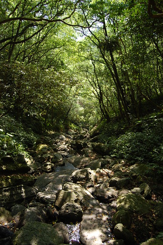
At the beginning the trail headed steeply up and then after half an hour or so it leveled out. This part was nice enough but it's forested and so there were no views. After a while we came to a landslide and from there we could see our destination. (I think!)


Continuing up we began realised just how popular this trail is. I would guess at least 300 people were up there and they were all very friendly! It's amazing to hear 70+ year olds telling you that you're "hao li hai" for climbing up the exact same mountain as them!
After about three hours of hiking, we arrived at a large tree. Just after this there was a small stream and a crowd of people cooking up lunch. A few minutes later and we got to where a wooden hut used to stand (the hut no longer exists as it was used by hikers for fire wood) and from here the real climbing began.
After about three hours of hiking, we arrived at a large tree. Just after this there was a small stream and a crowd of people cooking up lunch. A few minutes later and we got to where a wooden hut used to stand (the hut no longer exists as it was used by hikers for fire wood) and from here the real climbing began.
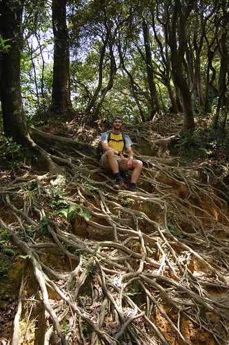
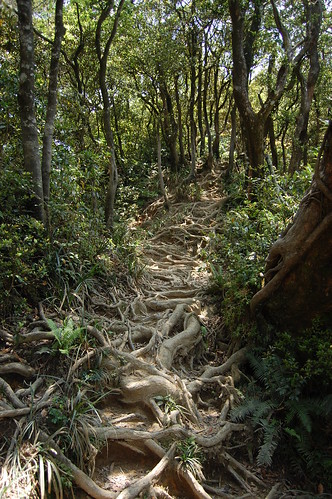
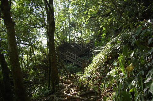
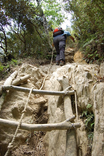
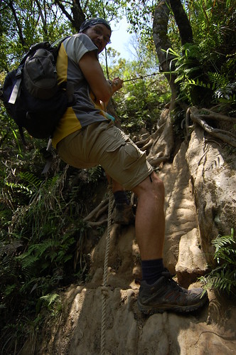
Crisscrossing the trail were the exposed roots of trees which makes for a strange sight. There were lots of roped sections and homemade ladders. In parts it was pretty slippy and, although I've seen blogs from when people climbed this in the rain, I should imagine that it's really difficult.
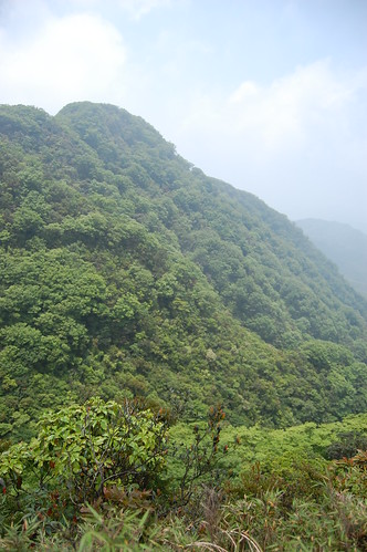
It took about four hours to reach the top. The view was good but it was a little bit cloudy and so we couldn't see much. We took a quick break and ate some lunch. Earlier on the trial we got talking to a guy who said that from the peak you could continue on to Duo ai shan 多崖山 and then return in a loop back to Manyueyuan. We decided to give it a go.
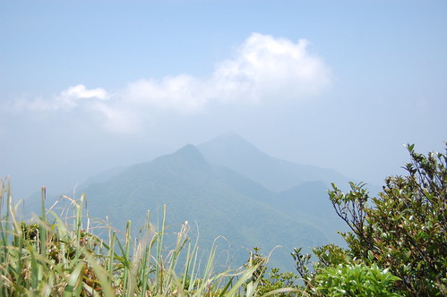
The trial round to Duo ai shan was great and included a vertical section to negotiate and it was definitely worth the effort. Once at the peak you are rewarded with 360 views of the surrounding mountains and valleys.

The trail then went steeply down and eventually passed through a beautiful forest of Chinese Cypresses. This section took about two hours to complete and by the time we met up with the trail at the landslide we saw earlier, we were exhausted! From there went back down to Manyueyuan to get well deserved ice-creams from the visitor centre. In all it took seven and a half hours and was very tiring but well worth it!
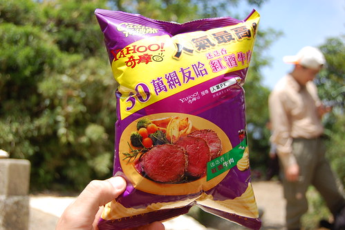 Just to illustrate the height; at the top my bag of crisps was almost ready to pop from the drop in pressure!
More photos here
My brother's Chinese version of the hike can be found here
Practicalities
Transport for those without a car or scooter is difficult. Try getting a taxi from Sanxia or Yongning MRT.
The visitor centre in Manyuyuan has snacks and drinks but for more substantial eating you need to bring your own.
It took us seven and a half hours and that was at quite a pace. From a lot of the blogs that I've seen, people often end up coming down the last parts in the dark and so it's best to have a torch and make an early start.


Great blog. Thanks for the info. See you at another hike soon.
ReplyDeleteHey,
ReplyDeleteI lived in Nantou County last year and I loved the time I spent in the mountains. I always wanted to do the CiLai ridge from the north peak to the south peak. I never got a chance because my friend said it was too dangerous...I'd love to see it if you ever go.
I've heard that about Cilai. I'd love to go there, hopefully i'll get a chance although I think at the moment the trail is closed from last year's typhoon damage.
ReplyDelete